The Biographies of Eminent Monks Home Page
Maps of the Journeys Undertaken
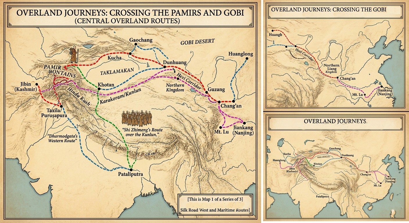
Map 1: Overland Journeys via the Pamirs and Gobi
This map focuses on the courageous individuals, both Indian monks and Chinese pilgrims, who traversed the extreme terrains of high mountain passes and desert wastelands to reach their destinations in the early 5th century.
Who is Featured:
- Faxian (The Red Path): The map details his departure from Chang'an, his journey along the northern Silk Road through Dunhuang and Kucha, the harrowing crossing of the Pamir Mountains (The 'Onion Range'), and his entry into Northern India.
- Shi Zhimeng (The Green Path): Similar to Faxian, he and his large entourage are shown crossing the Pamirs from the Western Regions to reach Pataliputra.
- Dharmodgata (The Blue Path): His distinct eastern departure from Huanglong is highlighted, connecting with the Silk Road before navigating the Pamirs.
- The Kashmiri Monks (Saṁghabhūti, Saṁghadeva, and Dharmayaśas - The Magenta Path): This route visualizes the standard movement from the Jibin region (modern Kashmir/Gandhāra) across the mountains to the northern Chinese capital of Chang'an.
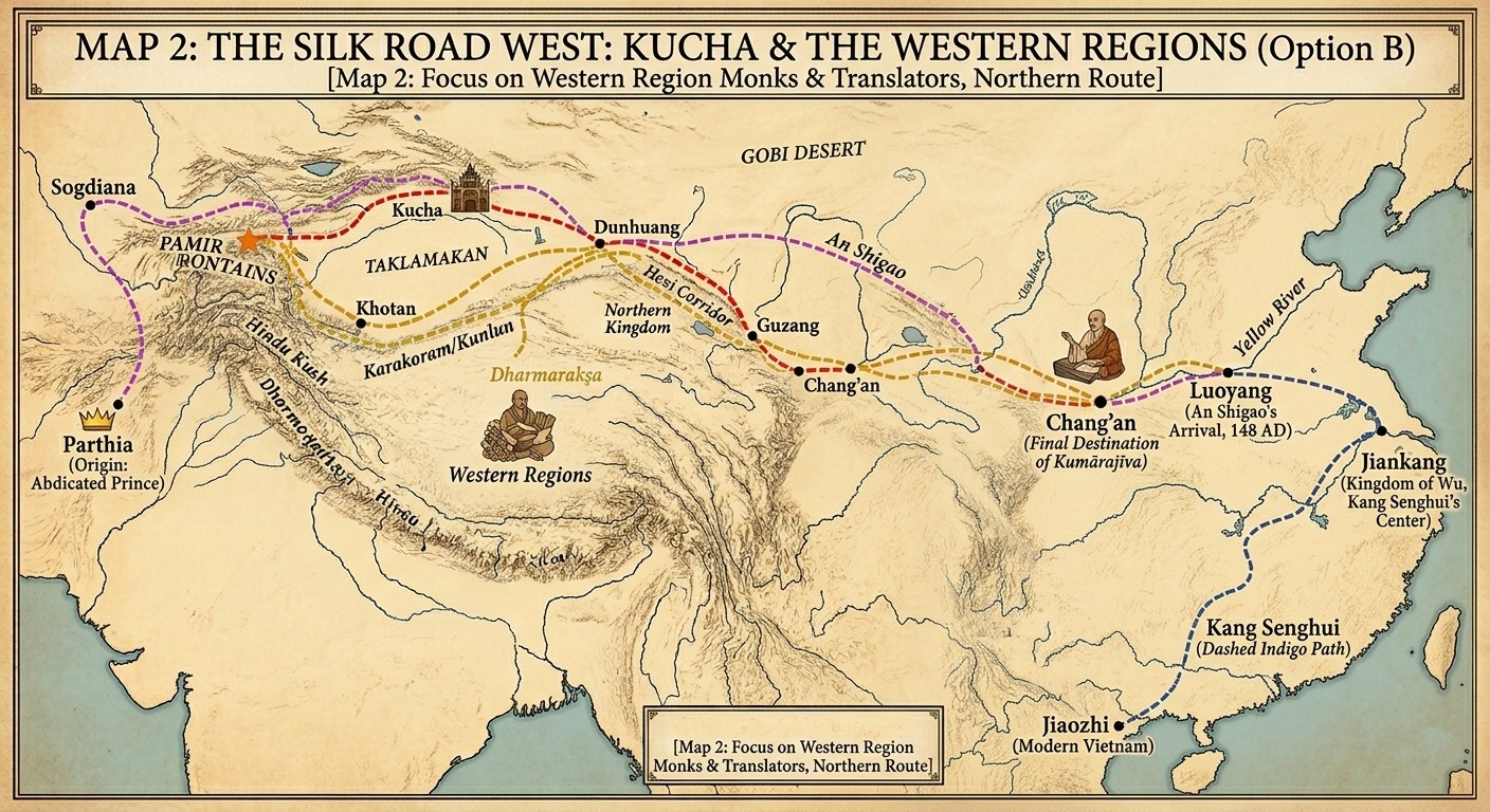
Map 2: The Silk Road West: Kucha & the Western Regions
This map shifts focus to the Northern branch of the Silk Road and the profound movement of monks from Central Asia and Northern India into the heart of China. It visualizes the flow of people and ideas that fueled the great translation movement.
Who is Featured (using distinct, dotted paths):
- Kumārajīva (The Dotted Orange Path): His path is prioritized, showing his long journey from his birthplace in Kucha, through Guzang (where he was held in the Northern Liang kingdom), to his final destination and translation center at Chang'an. A small icon of Kumārajīva translating scriptures is placed in Chang'an.
- An Shigao (The Dotted Violet Path): This path details his epic journey from his origin in Parthia (marked with a crown icon and labeled 'Parthia (Origin: Abdicated Prince)'). He crosses the high Pamirs and the Taklamakan (the Northern Route) before traversing the Hexi corridor to reach Luoyang, the Eastern Han capital, in 148 AD.
- Kang Senghui (The Dotted Indigo Path): This route highlights the unusual path from Jiaozhi (modern Vietnam, shown with a family route from Sogdiana and India). His main path leads north, bypassing other major hubs, directly to Jiankang (Nanjing) in the Kingdom of Wu.
- Dharmarakşa (The Dotted Gold Path): Rather than a linear origin-to-destination route, this path visualizes his constant, extensive travels based in Dunhuang, moving back and forth between Khotan, the Western Regions, and the capital, Chang'an. A small icon shows him with numerous scrolls.
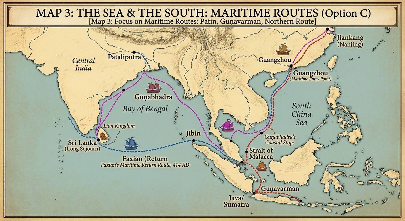
Map 3: The Sea & the South: Maritime Routes
This map highlights the growing importance of the sea routes during the 4th and 5th centuries, showing how Buddhism reached the southern Chinese capitals through the "Maritime Entry Point" of Guangzhou.
Who is Featured:
- Faxian (The Dotted Blue Path): This route focuses exclusively on his return journey. After years in India, he traveled to Sri Lanka (staying for two years), then boarded a large merchant ship to cross the Indian Ocean to Java/Sumatra, before finally sailing north to land at Guangzhou in 414 AD.
- Guņabhadra (The Dotted Magenta Path): A native of Central India, his path shows a departure from the Indian coast, a crossing of the Bay of Bengal, and a transit through the Strait of Malacca. He is shown making several coastal stops in Southeast Asia before reaching Guangzhou and moving inland to the Liu Song capital.
- Guņavarman (The Dotted Red Path): Originally a prince from Jibin (Kashmir), his unique maritime route shows him traveling first to Southeast Asia (specifically Java, where he converted the local royalty) before being invited by the Chinese Emperor to sail to Nanjing (Jiankang) to establish the bhikshuni (nun) lineage.
The maps and summaries were generated by Gemini, but were re-edited to correct mistakes, remove unwanted material, etc.
